INTRODUCTION
Sustainable industrialization rests on the availability of energy (Dudhani et al., 2006; Fan et al., 2013; Khan and Zaidi, 2015). This energy could be obtained from fossil fuels (with concerns over environmental degradation), large hydropower projects (with concerns of displacement of land and population), and nuclear fuel (with environmental problems). The ever-growing need for power warrants us to explore alternative energy sources. Amongst these alternative sources, stands hydropower on a smaller scale (small, mini, and micro hydropower), given in Table 1, which sustains growth in the power sector. The small hydropower projects need low initial investments, smaller area, shorter planning and construction time, locally trained manpower, indigenous material, and lower power generation cost as compared to larger power projects (Dudhani, et al., 2006). Hydropower in general is an environmentally clean and renewable energy source, contributing by negligible amounts to Green House Gas emissions and other atmospheric pollutions (Dudhani et al., 2006). About 20% of the electricity of the world is hydropower (Raghu, 2015). The hydropower potential of Cameroon is estimated at 35 GW, of which only 2% had been developed. It is worth noting that 67% of all electricity generated in the country in 2007 was hydroelectric power (Nations et al., 2009). It is estimated that more than half of the population of Cameroon does not have access to electricity. Extremely, 80% of the rural areas do not have electricity. This problem is further compounded by the fact that there are no national grids, so 20% of the generated power is lost during transmission and distribution (Nations et al., 2009). Thus, the development of Small Hydro Systems in Cameroon will be a welcome relief for these rural areas, given that hilly areas with rainy climatic properties have enormous hydropower potential (Coskun et al., 2010).
|
Table 1. Classification of Hydropower According to Generating Capacity (Tarife et al., 2017).
| Hydropower Class |
Generating Capacity |
| Large |
> 100 MW |
| Medium |
25 – 100 MW |
| Small |
1 – 25 MW |
| Mini |
100 kW – 1 MW |
| Micro |
5 – 100 kW |
| Pico |
< 5kW |
|
The main motivation for this study is the desire to see an improvement in the lives of the people living within this area. Power cuts in Yabassi are very rampant and most of the time, they last for more than two months. The inhabitants resort to burning firewood for domestic activities (harming the environment), solar lamps, and kerosene lamps, as well as generators. Because access to Yabassi is difficult, goods like petrol, kerosene are very expensive. It is also the wish of many that the area should re-experience development, and only the continuous availability of electricity can guarantee it.
Advances in computer technology, with the appearance of Geographic Information System (GIS), in conjunction with rainfall-runoff hydrologic model, usher a variety of hydrological applications, including but not being limited to the drainage pattern delineation in a catchment (Coskun et al., 2010; Dudhani et al., 2006; Kulkarni and Banerjee, 2011; Mirchi et al., 2010; Raghu, 2015). Remotely sensed maps, specifically Digital Elevation Models (DEMs), are analysed to obtain most of the hydrological parameters. The hydrologic model was developed to get the estimated runoff depth and corresponding hydrograph around the gauging station. The design discharge was also estimated for the watershed within the reach of interest, from where the dam is to be constructed. The hydropower capacity for the particular reach is calculated and the design is performed, including a proposed site for construction.
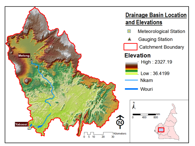
The Catchment Basin of interest drains a very large area, which cuts across four Administrative Regions of Cameroon, which are the Littoral Region, the Centre Region, the South West Region, and the West Region. It is located within 4.35 – 5.81 degrees North latitude and 9.59 – 11.96 degrees East longitude and covers a surface area of 8,192 km2. The predominant river is the Nkam River, which becomes the Wouri River in the downstream of the catchment. The catchment basin is shown in Figure 1. The climatic condition is of equatorial type, with monthly average temperatures between 22.64 °C and 28.04 °C, and monthly average precipitation depths between 1 and 92 mm.
DATA AND METHODOLOGY
The methodology generally consists in obtaining elevation and meteorological data and analysing; developing and calibrating/validating the model with discharge data at a gauging station; calculating a theoretical value for the potential hydropower of the envisaged area and using multi-criteria analysis for the selection of the hydropower plant site, and calculating the value of the hydropower potential to export to the central grid.
Delineate and Calculate Catchment Parameters
This first phase of the project makes use of the Watershed Modelling System (WMS) software to obtain hydrological and geometrical parameters of the drainage basin. WMS has web-based data acquisition tools that give access to some of the data required to set and run a hydrologic model as well as a hydraulic model. Using the step-by-step hydrologic modelling wizard of the software, web-service data were downloaded, including Shuttle Radar Topographic Mission (SRTM) – 3-arc-second resolution elevation map, topographic map, as well as soil data and land cover data. Flow directions and flow accumulations were computed by the software, and outflow points chosen. The catchment basin, which is the upslope area that drains to the outlet, is automatically delineated in WMS. A desired modelling approach is selected to simulate processes within the delineated drainage basin.
The HEC-HMS approach, which focuses on runoff, channel routing, and water control structures, is chosen and a (numerical) model is built from the hydrologic and geometric parameters of the catchment basin. This approach is suitable for events and not for long simulations. The resulting model is simulated in the HEC-HMS software, for known hyetographs, using the National Resource Conservation Service – Curve Number (NRCS-CN) method. Conceptually speaking, the NRCS (formerly, the SCS) method converts a hyetograph into a hydrograph, influenced by soil properties, land cover, abstractions, ground slope, and other factors within the catchment area. It is one of the enduring methods for estimating direct runoff volumes in poorly gauged or ungauged catchments (Fan et al., 2013). Precipitation depths are obtained from the localized weather station at Yabassi. The catchment basin is poorly gauged with just one rainfall data centre, covering the whole of the watershed. If other nearby meteorological stations were available, then the average basin rainfall would have been calculated by constructing Voronoi polygons (Raghu, 2015). The precipitation data are used to calibrate the model with the discharge data from Yabassi. The hydrologic model is validated by simulating reach discharge from the rainfall data. This discharge simulation is necessary to give an idea about the flow that the hydraulic structure will have to contend with. The NRCS method uses a unit hydrograph. It translates excess rainfall depth into a runoff flow. The required parameters to be calculated prior to running the hydrological model include but are not limited to the basin lag time (\(t_{L}\)) and the time of concentration (\(t_{c}\)). The formulas for these are given in equations (1) and (2) below:
| \[t_{L} = \ \frac{{(30.48*L)}^{0.8}{(S + 1)}^{0.7}}{1900\ Y^{0.5}}\] |
(1) |
and
| \[t_{c} = \ \frac{5}{3}t_{L}\] |
(2) |
where \(Y\) is the slope of the catchment basin (%) and \(L\) is the flow length (the longest path along which water flows from the watershed divide to the outlet) (cm).
The NRCS-CN method depends on the value of Curve Number (CN). The general runoff volume from this method is given by equation (3);
| \[Q = \left\{ \begin{matrix} 0 & , & P \leq 0.2S \\ \frac{{(P - 0.2S)}^{2}}{P + 0.8S} & , & P > 0.2S \\ \end{matrix} \right.\ \] |
(3) |
where \(P\) is precipitation (mm) and \(S\) is potential maximum retention (cm). \(S\) is defined in equation (4) as:
| \[S = 2.54\ \left( \frac{1000}{\text{CN}} - 10 \right)\] |
(4) |
In this study, the value of \(\text{CN}\) for the catchment (and sub basins) was calculated using an approach similar to that presented by Fan et al.,(2013). Though less sophisticated, it used the soil and land use data together with the TR-55 look-up tables on curve numbers produced by the Department of Agriculture’s NRCS of the United States of America. The method consisted in classifying the land use and soil type in terms of categories. Each combination of a land use category and a soil type category was attributed a value for an initial curve number from the TR-55 look-up table. The resulting composite curve number was calculated using the formula in equation (5):
| \[\text{CN}_{\text{composite}} = \ \frac{\sum_{i}^{}{\text{CN}_{i}*A_{i}}}{\sum_{i}^{}A_{i}}\] |
(5) |
where \(A_{i}\) is the area of certain combination of a category of land use and a category of soil type and \(\text{CN}_{i}\) is the correspondingly associated curve number.
Hydropower Theoretical Capacities and Plant Sites
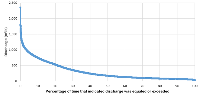
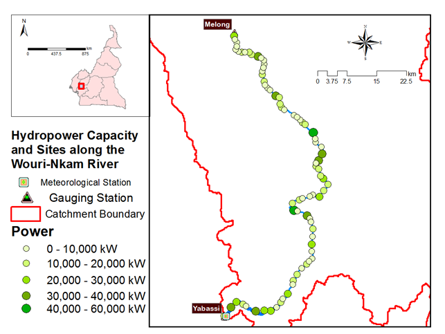
The choice for selecting construction sites for hydropower plants depends on the elevation difference and the discharge. These discharge and head values are evaluated using the method presented by Khan and Zaidi (2015). Given that a run-of-river hydroelectric plant is to be constructed, the water discharge and elevation drop are needed to generate hydroelectricity. In this regard, a small dam (intake) is built that conveys water from the main water channel to a pipeline or penstock. The penstock further directs the flow to a power house with a turbine. In this study, multiple possible locations for the hydropower plants are selected at a distance of 1000 meters along the river thalweg line, to mark proposed plant locations. The elevation of each site is extracted from a DEM, and the head difference for that site is the difference between the upstream elevation and the site elevation, where the upstream elevation is taken to be the intake point and the site elevation corresponding to the turbine location. In this case of discharge estimation for the various sites, use is made of the fifty percent exceedance (Q50) values from the two discharge points along the river. The Q50 value of the flow at Melong Gauging station is 38.05 m3/s while The Q50 value of the flow at Yabassi Gauging station is 167.74 m3/s. These two values are used to determine the discharge at the other sites. The theoretical power is then calculated for each of the sites. Multi-criteria analysis in QGIS is then used to select the appropriate site, depending on for example: the capacity of the energy, slope of the area, and others.
Calculation of Energy to Export to the Central Grid
The objective at this step is to analyse the technical and financial viabilities of possible projects, at the same time reducing the duration of pre-feasibility / feasibility studies (Kobbina, 2014). The hydropower plant together with some estimated dimensioning were accomplished through the use of the RETScreen 4 software suite. RETScreen is a Clean Energy Management Software system for efficient renewable energy and cogeneration project feasibility analysis as well as on-going energy performance analysis (Kobbina, 2014).
RESULTS AND DISCUSSION
The delineated dendritic catchment area was approximately 8,191.66 km2. Two outflow points were used to divide it into two sub-basins, given that only two discharge gages were available. Approximately 40% of the land use is made up of mosaic vegetation (50 – 70% grassland/shrub land/forest and 20 – 50% cropland) while 47% of the superficial area is made up of loamy soils (Soil Type Group A), giving the area a good infiltration rate. Thus the runoff depth that results from the net precipitation is not enough to cause flooding within the area, since the value for initial abstraction is reasonably large. With the high rainfall values for the catchment area, and the high retention, we realize that the area will have a correspondingly high value for the groundwater. It is this groundwater (base flow) that has been maintaining flow in the perennial streams of the likes of River Wouri.
The deterministic hydrologic model was calibrated and validated for precipitation and discharge data from Yabassi (the outflow point of the catchment basin) and Melong for 1951 - 1980. The calibrated peak discharge produced an absolute error of 3.4% and a Nash-Sutcliffe value of 0.301, for a simulation run of August 01, 1985 to August 31, 1985 from daily precipitation values and the validated design discharge gave an absolute error of 8.9%. This big validation error is most probably as a result of approximations from the rainfall data. Getting hourly rainfall data to use for both calibration and validation results in a validated model that reflects the natural catchment basin with the smallest error.
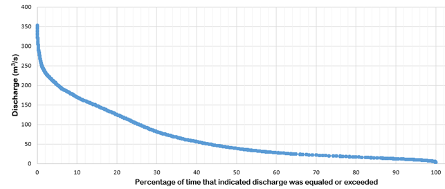
The Flow Duration Curves (plotted with mean daily discharge values) for the two gauged stations at Melong and Yabassi are shown in Figures 2 and 3 respectively.
The theoretical potentials of hydropower calculated along the Wouri-Nkam River is shown in Figure 4.
A design flow value was taken to correspond to Q69.8, from the flow duration curve of Figure 3. The gross head was chosen to be 20 m and the turbine type was Francis. The turbine peak efficiency was calculated to give 85.9% while the generator efficiency was estimated at 95%. The calculated power stood at 13, 813 kW. The capacity of power to be exported to the central grid is calculated at 111,180 MWh at $52.50 per MWh. The nominal flow was obtained from the flow duration curve of the flow in Figure 3. This flow corresponds to the flow value observed 120 days during a year. The compensation flow, which is the minimum flow in the river to sustain aquatic life, is calculated from the nominal flow to give 133.17 m3/s.
Renewable energy projects like the hydropower projects do contribute in mitigating the effects of climate change, by reducing the amount of carbon dioxide in the atmosphere. The gross annual Green House Gases emission reduction in terms of tons of carbon dioxide that will be obtained by implementing this project stands at 27,064.8. This is equivalent to 2,489 hectares of forest absorbing carbon dioxide.
CONCLUSION
The Kyoto Protocol advocates the production of renewable energies like the hydropower, but this hydropower generation passes through a number of stages. The most important of the steps concerns the hydrological analysis, which permits to get the geomorphic parameters of the area of interest as well as the available discharge for generating the hydroelectricity. A number of software were used to accomplish this step, including WMS, HEC-HMS, and QGIS, to delineate the area contributing in terms of runoff to the outlet point at Yabassi. It was also assumed that the rainfall depth is uniformly constantly distributed over the whole area, because only one meteorological station at Yabassi was used. Nonetheless, a reasonable estimate was made for the hydropower at 13,813 kW (due to advancement in remote sensing techniques) corresponding to Q69.8. It turned out that the projects along the Wouri – Nkam River vary between Small Hydropower Plant (with energy capacity between 1 and 25 MW) and Medium Hydropower Plant (with energy capacity between 25 and 100 MW). This study will aid decision-makers in making informed judgements concerning improvement in the available energy of the country to reduce load shedding. The developed blueprint will be used to assess the hydropower potential of the country in general.
A detailed feasibility study will have to be carried out to better plan a harnessing approach and cost-effectiveness of the project. This include doing comprehensive geologic, geomorphic, seismic, and geotechnical studies on the study area.
ACKNOWLEDGEMENT
We are indebted to the Xuan Thien Africa Investment S.A in Yabassi, through whom we received the discharge and precipitation data for this work. They are concerned with the designing and construction of hydraulic structures like dams, hydropower stations, and others, and are currently carrying out some feasibility studies on a part of the catchment basin
 Full Text (PDF)